At Plant Hatch, safety is our number one priority. Of all the things we do, we are first and foremost committed to ensuring the safety and health of our plant employees and neighbors. We have comprehensive emergency plans in place – in partnership with local, state and federal agencies – that prepare for the unexpected and provide layer upon layer of redundant safety features.
Another way we work to keep you safe is by making sure you know exactly how to respond in the unlikely event of a plant emergency. Please familiarize yourself with Plant Hatch’s emergency information to ensure you’re prepared to protect yourself and your family. We encourage you to bookmark this page on your mobile device. Use these tools to ensure you know how to react in the event of an emergency. Safety is our first value at Southern Nuclear and your family's safety is our priority.
CodeRED Emergency Notification System
The CodeRED Emergency Notification System may be utilized to contact residents by phone in the event of an emergency. It is also available as an app on your smart phone. For additional information, visit OnSolve's CodeRed.
If you reside within the 10-mile emergency planning zone of one of our nuclear facilities, please visit your respective site to learn about information sources, checklists, emergency routes and reception centers.
Hatch Emergency Information Packet (PDF)
Our annual emergency information packet provides the comprehensive information you need to respond safely and quickly. In coordination with our local emergency management agencies, we ensure you have all of the information you need in one handy location.
FAQs
Who is Involved in the Emergency Plan?
State and local government agencies have plans to protect you if there is an emergency at Plant Hatch. Organizations involved in emergency planning are:
- Appling County Emergency Management Agency
- Jeff Davis County Emergency Management Agency
- Tattnall County Emergency Management Agency
- Toombs County Emergency Management Agency
- Georgia Emergency Management and Homeland Security Agency
- Georgia Department of Natural Resources
- Georgia Governor’s Office
- Georgia Power
- Southern Nuclear
Any serious emergency would generally develop over time. There would normally be plenty of time for you to be notified and take action.
Emergency Contact Information
Please call 800-262-5283 to hear updates throughout the duration of the event. GeorgiaPower.com will be updated with the latest information about the emergency. To report rumors during an emergency, residents are asked to please call 888-823-0406.
State and county 24-hour contact numbers:
Georgia Emergency Management and Homeland Security Agency
800-879-4362 or 800-TRY-GEMA
Appling County Sheriff
912-367-8120
Jeff Davis County Sheriff
912-375-6600
Tattnall County Sheriff
912-557-6777
Toombs County Sheriff
912-526-6778
For questions about state and local emergency plans contact:
Georgia Emergency Management and Homeland Security Agency
gema.georgia.gov | 800-879-4362 or 800-TRY-GEMA
Appling County Emergency Management Agency
applingema.com | 912-367-8170
Jeff Davis County Emergency Management Agency
jeffdavisema.com | 912-375-6628
Tattnall County Emergency Management Agency
tattnallcountyga.com/emergency-management-agency.cfm
912-557-6820 | Tattnall County EMA Facebook
Toombs County Emergency Management Agency
912-526-6424
For more information about the Plant Hatch Emergency Plan, please call Plant Hatch Emergency Preparedness at 855-880-2058.
Emergency Alert Stations
Radio
WUFE-AM 1260 Baxley, Ga.
WBYZ-FM 94.5 Baxley, Ga.
WHJD-FM 105.9 Hazlehurst, Ga.
WTCQ-FM 97.7 Vidalia, Ga.
WYUM-FM 101.7 Vidalia, Ga.
WVOP-AM 970 Vidalia, Ga.
Television
WSAV-TV Channel 3. Savannah, Ga.
WTOC-TV Channel 11 Savannah, Ga.
WJCL-TV Channel 22 Savannah, Ga.
Social Media
Facebook: http://facebook.com/georgiapower
Twitter: @georgiapower
LinkedIn: linkedin.com/company/georgiapower
False Alarms
A false alarm of the emergency sirens is possible because of lightning or other events. If you hear the emergency sirens and there is NO emergency information on an emergency alert station, then the alarm is probably false.
If this happens, please call the local emergency management agency office with any questions
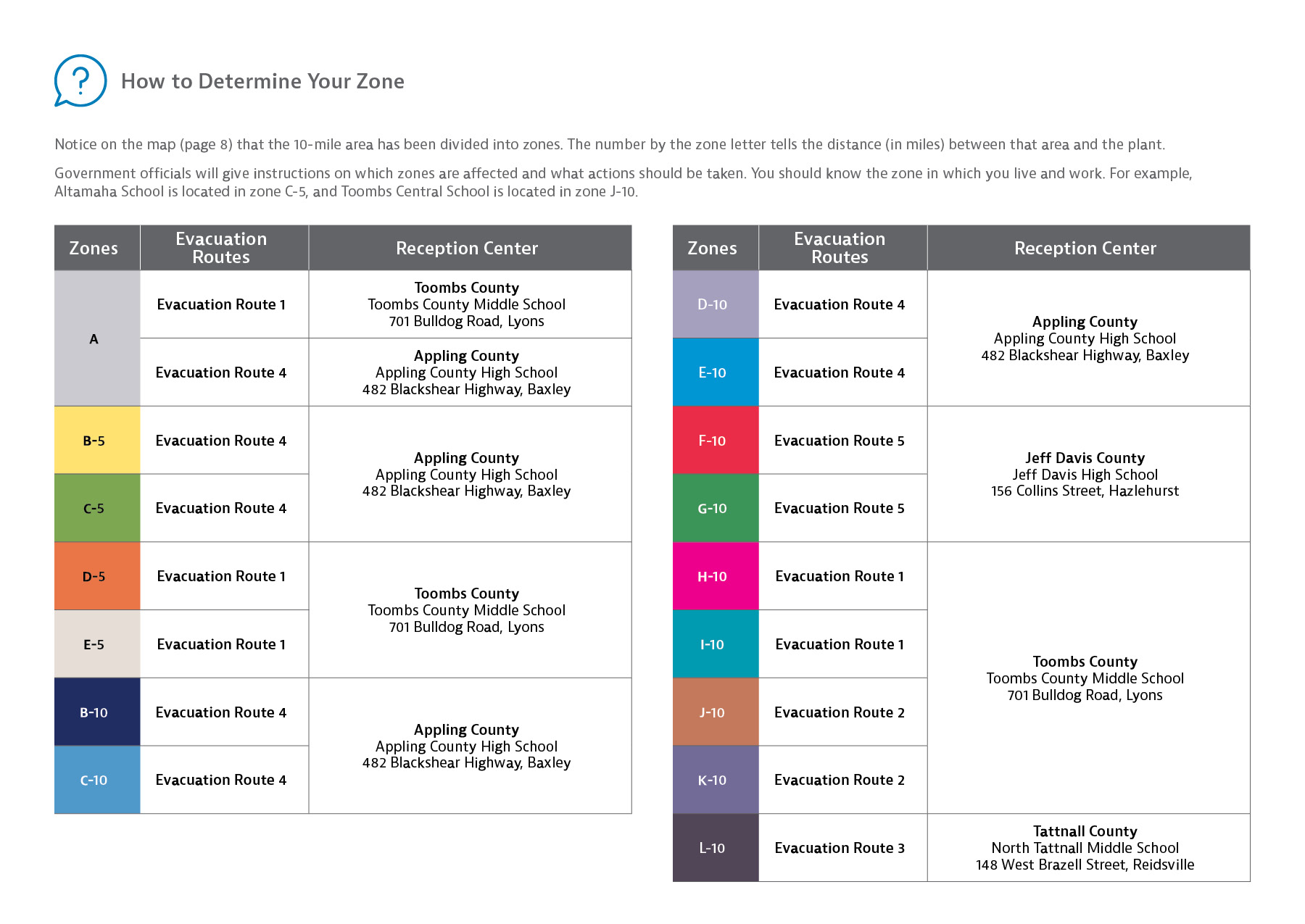
Evacuation Routes and Information
Evacuation routes will depend on weather conditions and will be announced on radio and television. There will be no need to rush, so obey posted speed limits.
Evacuation Route 1 —Toombs County
(West of U.S. Hwy 1) U.S. Highway 1, north to County Road 115 (Aimwell Road Ext.), west to 701 Bulldog Road, Lyons, north to Toombs County Middle School:
- County Road 364 (Cedar Crossing-Alston Road), north to County Road 78 (Cedar Crossing-Vidalia Road), north to U.S. Highway 1
- County Road 97 (South Thompson Road), north to U.S. Highway 1
- County Road 78 (Cedar Crossing-Vidalia Road), north to U.S. Highway 1
- Georgia Highway 56, east to U.S. Highway 1
- Georgia Highway 147, west to U.S. Highway 1
- County Road 336 (Old River Road), east to U.S. Highway 1
Evacuation Route 2 —Toombs County
(East of U.S. Highway 1) Georgia Highway 178, north to U.S. Highway 1, south to Parker Avenue, west to 701 Bulldog Road, Lyons, south to Toombs County Middle School:
- Georgia Highway 147, east to Georgia Highway 178
- Georgia Highway 56, east to Georgia Highway 178
- County Road 332 (Marvin Church Road), north to County Road 333 (Johnson Corner Road), north to Georgia Highway 178
Evacuation Route 3 — Tattnall County
Georgia Highway 147, northeast to North Tattnall Middle School:
- Georgia Highway 178, north to Georgia Highway 147
- County Road 184 (P.E. Davis Road), County Road 185 (Elza District Road), County Road 183 (I.S. Smith Road), northeast to Elza District Road to Highway 147
- County Road 186 (Edwin Phillips Road), County Road 189 (Peach Tree Road), east to County Road 192 (Cedar Haw Road), north to Highway 147
- County Road 626 (Maple Drive), County Road 187 (Catherine T. Sanders Road), south to County Road 188 (Old River Road), east to Highway 178, north to Highway 147
Evacuation Route 4 — Appling County
U.S. Highway 1, south to Georgia Highway 15, south to Appling County High School:
- County Road 3 (West River Road), east to U.S. Highway 1
- County Road 538 (Altamaha School Road), south to U.S. Highway 1
- County Road 537 (Ten Mile Road), south to Georgia Highway 144, south to U.S. Highway 1
- County Road 1 (Nails Ferry Extension Road), south to County Road 1 (Nails Ferry Road), south to U.S. Highway 1
Evacuation Route 5 — Jeff Davis County
County Road 203 (Altamaha Road), west to U.S. Highway 341, south to U.S. Highway 23 (Contos Boulevard), south to Jefferson Street (Alma Highway), north to Broxton Highway, west to Jeff Davis High School:
- County Road 245 (Owl Head Road), east to County Road 185 (Graham Road), south to County Road 203 (Altamaha Road)
- County Road 223 (Bullard Creek Road), west to County Road 185 (Graham Road), south to County Road 203 (Altamaha Road)
- County Road 185 (Graham Road), south to County Road 203 (Altamaha Road)
- County Road 185 (Graham Road), north to County Road 203 (Altamaha Road)
- County Road 301 (Will Waters Road), west to U.S. Highway 341
- County Road 182 (Mt. Zion Church Road), south to U.S. Highway 341, east to U.S. Highway 23 (Contos Boulevard)
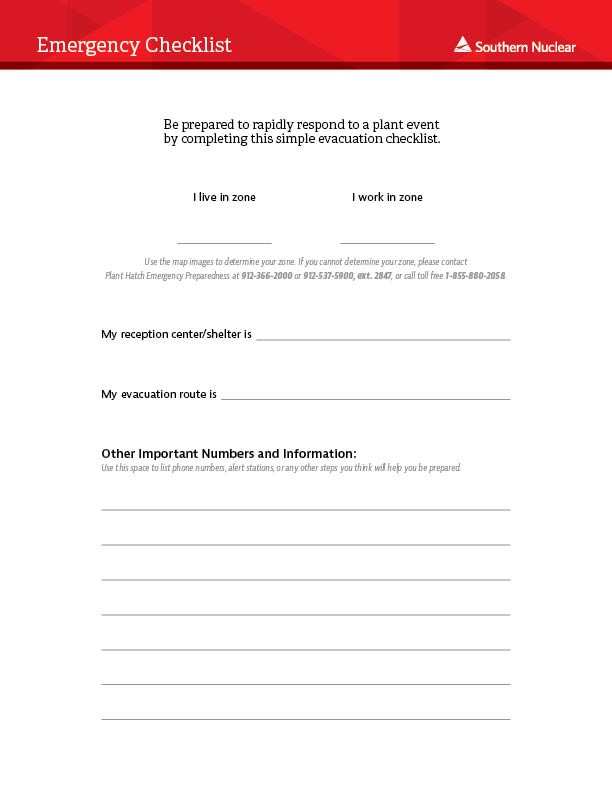
Emergency Checklist
Be prepared to rapidly respond to a plant event by completing this simple evacuation checklist.
Click the image to download a PDF ready for you to fill out.
Emergency Planning Zone Map